

Be a modern artist: pick a busy intersection and proclaim it your masterpiece. The critics love it, applaud your sense of color. . . . Like the best art, it was right in front of you all along but now you see it for the first time. Like the best art, it will outlast you. Colosn Whitehead, The Colossus of New York; A City in Thirteen Parts [New York: Random House, 2003] 79)
I must confess it took me a long time to find an intersection in Phoenix that I felt matched Whitehead’s marvelous injunction, and when I did, it turned out to be one I had crossed through several times a day for almost forty years. At first I thought it might be the ground zero of Phoenix, Central Avenue and Washington Street, but that intersection was only symbolic and held little of interest to me. A quick glance at the map of Phoenix—the City of Phoenix, of Metropolitan Phoenix, of Greater Phoenix—reveals it to be almost a perfect checkerboard, with major streets laid out every mile, and, going north and south, secondary and tertiary streets, respectively, every half and quarter mile; these are named streets, and as in most cities, the names are a mixture of national historical figures like presidents, local movers and shakers like founding fathers and famous politicians, and names evocative of the local setting: I happen to live on Palm Lane, a street festooned with imported palm trees that were part of the taming, through greening, of the desert. Running east and west, with only a few exceptions, the streets are numbered, odd numbers dominating to the west of the Central Avenue axis; even streets dominating to the West. Of course, satellite cities are free to have their own naming and numbering system, but this is generally only true in the Southeast Valley.
Because of the symmetrical geometry of the city, I was attracted to Grand Avenue, especially where it runs in at a perfect 45 degree angle at West Van Buren and North 15th Avenue. Grand Avenue is the continuation of U.S. Highway 60 that, prior to its reassignment to the Superstition Freeway, came into Phoenix from the East through Apache Junction, along Apache Boulevard, angling north up Mill Avenue through downtown Tempe and then east along Van Buren, until you came to Grande Avenue, which takes you northwest toward Los Angeles. Because of the Interstate Highway system, it is rare for anyone to get to LA via Grand Avenue: Interstate 10, with which the Superstition Highway now connects and which runs in a straight line west just south of McDowell, less than a mile north of Van Buren, will take you nonstop to the Pacific Palisades. But urban development, while it has left some interesting remnants at this intersection, has also left vacant lots, the bane of downtown Phoenix (someone once said downtown Phoenix looks like Beirut after the war, although things have gotten better in recent years).
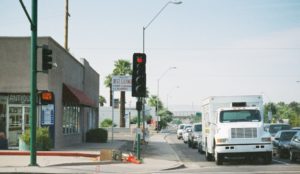
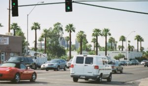
In my search for a street corner where there were archeological traces, so to speak, of Phoenix history and an interesting urban mix, I found I could do no better than the major intersection right down the street from my house, an intersection so busy that only an infrared camera in the wee hours of the night might be able to capture images without traffic and one that regularly hosts automobile accidents than can be heard from inside one’s home with even the summer air conditioning running nonstop.
Seventh Avenue and McDowell Road is the intersection of four historic areas in Phoenix: Roosevelt (the SE quadrant), F. Q. Story (the SW quadrant), Willow (the NE quadrant), and, the most renowned, Palmcroft-Encanto (the NW quadrant).
McDowell Avenue (West McDowell at this point, as it lies one mile to the west of Central Avenue) is named for Major General Irwin McDowell whose name was attached to the army post established in 1899 on the eastern edge of what is now the street that bears that name. Such army posts were part of Phoenix’s origins in the post-Civil War Indian Wars in Arizona, a locale that was chosen because of the then flowing Salt River and the absence, at the locale that was to become Phoenix, as any Indians, hostile or otherwise. When Phoenix began to experience the Post-World War I prosperity that led to a major spurt in its growth, the city ended at McDowell, and around Central Avenue there were some of the city’s first privileged sub-urban residential areas and lots of orchards and farm lands. The Palmcroft-Encanto area, which is reputedly the city’s first attempt at a planned residential community, was built up in the late 1920s and early 1930s and was, at that time, outside city limits. The northern edge of McDowell at this point contains the remnants of California-style courtyard apartments, which share an alley with the upscale Palmcroft development; the southern side of the street, which shares an alley with a more modest but solidly middle-class residential area that was within the city limits, mirrors the north side of the street in part.
The cross street is Seventh Avenue, which has become one of the major north-south arterials in the city, much to the consternation of residences that were once constructed along both sides of it when it was a tranquil city street. Backing out into the oncoming traffic is a decided challenge, and it is not surprising that many of what were once residences have become small business offices and professional installations (the same is true also of what were once homes along McDowell). Everytime one of the homes is sold for use as a doctor’s or a lawyer’s office, residents become divides over the losing battle of saving the edifices as historical houses vs. those who understand that they only continued to generate tax revenue if used commercially—otherwise they are likely to stand abandoned, which no one wants.
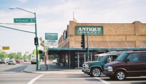
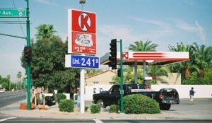
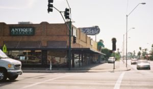
The four corners of Seventh Avenue and McDowell bear the traces of what was the original urban village development of the city. As late as 1969, when I bought into the area, the four corners boasted, respectively, on the northwest side a Mobile gas station that has since become a Circle K convenience story. On the northeast corner there is a shopping complex that housed multiple business that included a grocery store, a beauty salon, and a florist, which have since become, after passing through other stages, an antique fair and an ever expanding bakery-café/bistro-upscale fruit and vegetable mart. Yet, this latter building was not one of the first supermarkets in Phoenix. That honor seems to go to Golds, which was located in a building that is still standing and has been recycled nearby at West Roosevelt and North Third Street.
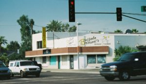
Continuing with the intersection, the southeast corner is also occupied by a large building that included a pharmacy that is now also an antique fair, although Best Cleaner behind the pharmacy going south on Seventh Avenue is still in business and has been continuously for seventy years. The southwest corner also contains two business that have been there, seemingly, for time immemorial: the Emerald Lounge and Runyon’s appliances, both of which have had a decided down-at-the-heels appearance for as long as I have known them. There used to be a gas station also on this corner, and its building was a fast-food outlet for several decades, but the latter business is now closed, and there is now a project to recycle the property for an upscale use.[1] This may mean the disappearance of the Emerald Lounge, a fact that should provoke mixed feelings, since, while for many it is an eyesore, it is, nevertheless, the only neighborhood-style bar in the area and stands in vivid contrast to the upscale watering hole that is the aforementioned café/bistro.
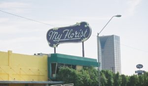
Certainly the most colorful anchor of this intersection is actually located a bit east on West McDowell Rd., and that is the My Florist café/bistro. My Florist was originally a flower shop run by a flamboyant Jewish woman who established it when she came out from New York in the 1940s (apparently, the area had a Jewish character, as the second known Jewish synagogue—the first is a still-standing structure a little over a mile away by the Phoenix Public Library; it is undergoing restoration—is a half-block away on the northwest corner of West McDowell and North Fifth Avenue, where it has served for years as a pawn shop whose large sign over the door and up steep steps from the street supposedly covers a glass-block menorah). When the owner of My Florist died, the flower shop closed, but the tall garishly lit sign was never removed. The new occupants of the property, who have cultivated a booming business that both oldtimers and well-heeled newcomers can’t seem to get enough of, chose to keep the sign and its name for their establishment. This quirky detail, especially the juxtaposition between the gleam and gloss of the café/bistro and its accompanying operations and the kitsch (echt bygone advertising and therefore not retro), is one of the particular attractions of the business. Because of the height of the sign, it dominates the area immediately around the intersection, where there are as yet highrises, much like the old water tower dominates the landscape of small town America. What one does have in this area beyond the My Florist sign is the only tall building in the neighborhood is, up on Central and Palm Lane, on the southwest corner, the interesting building originally built for the Dial Corporation, but now occupied by Viad; one of the most notworthy features of the property is the whimsical human sculptures in the green park that fronts it (these sculptures are continue on into the foyer of the building).
Palm Lane at Seventh Avenue is also noted for another local curioristy: the Statue of Liberty House on the southwest corner. This is a house that was built as a duplicate of one that was taken out of the Moreland corridor at the time of the construction of the through-town segment of the Interstate 10 freeway in the early 1970s. For reasons that have never been clear to the neighbors, many of whom are appalled by this example of non-Arizona kitsch, the owners decided to add this note of patriotic décor, complete with illuminated torch that at least makes giving directions for the intersection easy. Whenever I take a cab to my residence just a block and a half down Palm Lane from Miss Liberty, the driver usually knows exactly where I mean.
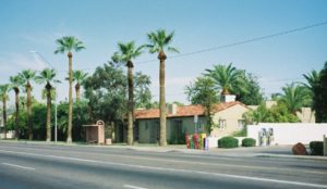
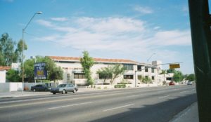
Since the major feature of the area around the McDowell/Seventh Avenue intersection is the prized Palmcroft-Encanto historical area, it is important to sense its presence in the lush greenery northwest of the Circle-K convenience store. Immediately to the north of the Circle-K store there is a modern office building that displaced some of the residences along Seventh Avenue mentioned previous (the ones that are, with the growing traffic flow, less and less desirable as homes and more and more susceptible to zoning requests for nonresidencial use). This office building was someone’s bad business investment, and it stood empty for almost two decades before recently being recycled as the Metropolitan Arts High School, part of Arizona’s burgeoning charter-school movement: many of the charter schools occupied so-called reclaimed space such as this office building, being unable to finance free-standing and individually tailored buildings. I have not heard of any squabble over such a semi-commercial use of this space (in the main the charter schools are proprietary operations), although I suspect that the neighbors tend to be of the political persuasion that supports the charter school movement.
Beyond the Circle-K to the northwest, then, and immediately west of the office building housing Metropolitan Arts lies the southeast corner of the Palmcroft-Encanto area, which extends from Seventh Avenue west to Fifteenth Avenue from the alley behind the buildings on McDowell north to Encanto Boulevard, the latter being the southern edge of Encanto Park (there is also a small extension of the Park south of Encanto Boulevard along part of Fifteenth Avenue that result from the developers need, at the time of the depression, to generate capital by selling the property to the city). Palmcroft-Encanto serves as home to important figures in the life of the city, including younger owners who want almost a century’s worth of charm and who are uninterested in commuting from the Acadia/North Scottsdale/Paradise Valley areas that developed as the central core became unattractive in the 1950s as the preferred residential area of the moneyed class). More importantly, it has had some important names associated with it, such as Barry Goldwater, who had a mansion there prior to moving, as his political career soared, to the Country Club preserve and then to Paradise Valley; Supreme Court Chief Justice John Rhenquist; and early powerbroker Frank Snell. Attorney General Bruce Babbitt, Governor Jack Williams, and legendary politician Renz Jennings also lived in the area. Although the area suffered some abandonment (more the Encanto half, which runs from the northern side of Palm Lane to Encanto Boulevard) with the exodus north and northeast beginning in the 1950s and 1960s, it became one of Phoenix’s first thirty or so official designated historical districts, and its integrity is now guarded by homeowners and their occasionally quite zealous spokespersons..
The importance of the Palmcroft-Encanto area has also helped the preservation of other historical areas that were originally more modest in their origins, such as the Willow area to the northeast of the McDowell/Seventh Street intersection and the F.O. Storey area to the south of McDowell on both sides of Seventh Avenue. Right down Seventh Avenue from McDowell is the Kennelworth Elementary School where Barry Goldwater was a student. After becoming almost a seedy inner-city school with the overall decay of downtown Phoenix in the 1960s, it is now an award-winning magnet school and an anchor for the Deck Park that covers the stretch of Interstate 10 that tunnels underground at this juncture. Conversely, the view south along Seventh Avenue from the McDowell intersection reveals the indicators of the presence of the freeway (signs, signals, and on- and off-ramp backed-up congestion) that cut the city in two and destroyed the southern edge of the residential area now known as the F. O. Storey neighborhood.
One of the important details of this intersection, and one of the principal reasons that I found it appropriate for this project, is the preservation of so much historical space. Except for the new building housing the Circle-K on the northwest corner, all of the other three corners are occupied by structures that have and have had multiple uses and that date back forty or fifty years at the least. These buildings can be viewed in two ways. The one on the northeast corner, which houses the larger of the two antique fairs and the now extensive operations of My Florist, is characterized by a second sidewalk parallel to the municipal ones on both Seventh Avenue and McDowell: it is probable that these sidewalks within the property line were constructed before the municipal ones were, which in most of the area appear to have been WPA installations (at least those along my stretch of Palm Lane bear the distinctive stamp of the Administration). Moreover, there is a building overhang that provides shade during part of the day to the sidewalk that L-s around the building. This sort of architectural detail is as significant as the sleeping porches in many of the houses in Palmcroft-Encanto (most of which have been converted in to so-called Arizona rooms), as concessions to the weather in an era before air conditioning and outdoor misters.
On the other hand, these buildings are construction nightmares—and, equally, I am certain—building code nightmares: they have been readapted so many times, with services upgraded so many times, that the visible cooling, plumbing, telephone, and electrical installations are as though the Centre Pompidou avant-la-lettre. This, of course, is a characteristic of many of the recycle and rerecycled buildings of Phoenix or any other city, for that matter. What makes this installation especially interesting is the use of the inner sidewalk and the way in which both the antique fair and My Florist have been able to capitalize on the permanence of this structure to create new anchors of the intersection. It remains to be seen if the proposed renovation plan for the southwest corner—with or without the reference point of the Emerald Lounge—harmonizes with the historical depth of the intersection and the surrounding neighborhood or whether it fragments that unity, as did the Circle-K with its thoroughly functional and this-could-be-anyone-of-our umpteen-thousand-stores design. The decision to build a Circle-K that reiterates an unvarying corporate image that is strictly functional, no matter where it is located, versus the decision to build a more-or-less unique structure that resonates with the human, architectural, and geographic context in which it occurs is crucial for how distinctive segments of the city—in this case, their instances of major arterial intersections—may choose to be: may choose to feel, may choose to be felt, and may choose to stand out distinctively from all the others
[1] The cityscape is a dynamic organism, never static and always changing. In the less than a month since I wrote this, Runyon’s and Buffalo Brown’s have been fenced off and torn down. My information is that the Emerald Lounge will remain, and that Starbuck’s will be building an outlet on the corner.